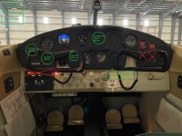
Upgrading plane to IFR suitable for training and practical exam

Jim Logajan

Administrator
Staff member
I'm planning to upgrade my 1956 C-172 to be IFR legal enough to learn and exam for an IFR rating. For navigation requirements my research indicates I could do it with a single WAAS GPS solution like a Garmin GPS 175 or GNC 355 tied to a HSI display. A local CFII suggested I should also install a unit capable of VOR, ILS, and marker beacon receivers and indicators. That roughly doubles the equipment cost (unless I go with a used Garmin GNA-430W) but I'm not sure it actually brings extra value equal to the extra cost. For example, VOR and ILS don't seem to provide any actual redundancy against GPS failures since many desired destination airports have only GPS approaches.

Opinions?
 
Opinions?
I don’t follow the pilot side, but I would check what are the current type of approaches one needs to show proficiency at to pass the check ride. Then figure what equipment you need to have. But as I recall you will need more than GPS nav ability.

From there you have options to control install costs, etc. For example, some people equip their personal aircraft in one configuration and rent an aircraft to take the check ride. Unfortunately there is no one answer to set up a bare minimum IFR aircraft and meet all your goals IMO.

However, if you’re open to used nav equipment vs the latest Garmin offerings you can get a lot of nav for the buck. For example, a used Narco NAV-122 will get you IFR capability for a decent cost. However, the problem is to find someone to install it as some shops won’t touch used stuff.
 
I don’t follow the pilot side, but I would check what are the current type of approaches one needs to show proficiency at to pass the check ride. Then figure what equipment you need to have. But as I recall you will need more than GPS nav ability.
I too had understood the need for more than GPS nav. But during my researches I discovered the FAA has recently rescinded two earlier legal interpretation letters in this 2022 memorandum and then made changes to Order 8900.1 that gave clearer definitions of "different kinds of approaches":
Clarification of Different Kinds of Approaches. Section 61.65(d) contains the aeronautical experience requirements for a person applying for an Instrument—Airplane rating. Section 61.65(d)(2)(ii)(C) states, in relevant part, that an applicant must complete 40 hours of actual or simulated instrument time that includes at least one cross-country flight that is performed under instrument flight rules (IFR) and involves “three different kinds of approaches with the use of navigation systems.” The FAA previously issued legal interpretations indicating that the three different kinds of approaches must utilize three different kinds of navigation systems. The FAA has since rescinded the legal interpretations. To fulfill the regulatory requirements, an applicant only needs to conduct three different kinds of approaches regardless of the navigation system utilized. Different approaches can be defined by the various lines of minima found on an approach plate. For example, localizer (LOC) minima are one kind of approach operation and instrument landing system (ILS) minima are another kind of approach operation. The same could be true of Area Navigation (RNAV) GPS-titled approach plates; a localizer performance with vertical guidance (LPV) approach is one kind of approach operation and a Localizer Performance (LP) to a circling MDA is another kind of approach operation. Subparagraph 5-433A3) above discusses the types of approaches. This paragraph also applies to § 61.65(e)(2) and (f)(2).
As best I can tell, the Order now defines a precision approach as any technology that provides sufficiently accurate vertical and lateral guidance to a Decision Altitude while a non-precision approach is any technology that provides sufficiently accurate lateral guidance and step-down points to a Minimum Descent Altitude. Both it and the latest Instrument Rating ACS appear to have been updated to be more technology agnostic. DME arcs for example can be demonstrated with RNAV substitution and Precision Approaches demoed with a GPS/WAAS LPV approach.
From there you have options to control install costs, etc. For example, some people equip their personal aircraft in one configuration and rent an aircraft to take the check ride. Unfortunately there is no one answer to set up a bare minimum IFR aircraft and meet all your goals IMO.
It is my understanding of the updated policy that a suitably certified GPS/WAAS Nav gets what I want for training, the practical exam, and real-world travel. Any additional equipment I might consider would be to provide redundancy against various types of failures.
However, if you’re open to used nav equipment vs the latest Garmin offerings you can get a lot of nav for the buck. For example, a used Narco NAV-122 will get you IFR capability for a decent cost. However, the problem is to find someone to install it as some shops won’t touch used stuff.
The Narco NAV-122 would be a good choice to equip for training and the practical exam. But for everyday cross-country flying it wouldn't get me into a lot of airports in IFR conditions. All but a couple dozen airports in the US that have instrument approaches have GPS approaches. According to an estimate posted here half the airports in the US have only GPS approaches. Plus, who wants to be limited to VOR routes when one can often fly direct?
 
Plus, who wants to be limited to VOR routes when one can often fly direct?
True. Perhaps check with your CFI and your check ride DPE to see if your GPS nav equipment selection will satisfy your regulatory requirement for your rating? Also be sure the IFR equipment requirements in 91.205 are installed and in working order before you start your training. And as a FYI, I would stay away from the 430W/530W units as Garmin has sunset certain repairs unless you can get one super cheap and treat it as a throwaway if the display goes TU.
 
I think I would want at least one other receiver that can work in the VOR MON in case GPS fails or is shut down. One of my rules is not to have a situation where my life would depend on a single point of failure. I suppose you could substitute a handheld with a VOR CDI and glideslope. But I would rather have a piece of certified equipment in the aircraft.
 
True. Perhaps check with your CFI and your check ride DPE to see if your GPS nav equipment selection will satisfy your regulatory requirement for your rating? Also be sure the IFR equipment requirements in 91.205 are installed and in working order before you start your training. And as a FYI, I would stay away from the 430W/530W units as Garmin has sunset certain repairs unless you can get one super cheap and treat it as a throwaway if the display goes TU.
Good point on the DPE. It was my plan to verify my installation plans with the DPE I was thinking of using for the exam.
 
I think I would want at least one other receiver that can work in the VOR MON in case GPS fails or is shut down. One of my rules is not to have a situation where my life would depend on a single point of failure. I suppose you could substitute a handheld with a VOR CDI and glideslope. But I would rather have a piece of certified equipment in the aircraft.
Of course redundancy is always desired. But consider the backups that existed for VOR or ILS/localizer failures prior to the advent of GPS. A prominent backup was contacting ATC for vectors to an alternate. That is still a good choice for GPS failure.

I started making a table with each row being a class of failure that would affect navigation in IMC (e.g. temporary GPS outage, GPS radio failure, com radio failure, total electrical failure, etc.) and columns for possible mitigations. I didn't get far before realizing that a hand-held battery powered radio offered mitigation for worst of the failures. (Along with judicious choice of alternate - ideally a forecast for VFR at ETA at the alternate.) I did note that a total electrical failure would also cause loss of transponder and ADS-B out, presumably making one invisible to secondary radar. Presumably ATC might still track the plane.
 
Back
Top