The fog and low clouds definitely caused frustrating problems for people attempting to travel in and out on the weekend. I'll let everyone tell their own stories - if they choose - and tell only mine.Goofy said:Glad to hear! Would be a nice event to schedule for later in the fall when the coastal weather is perfect. Half Moon Bay would be another good one.
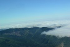
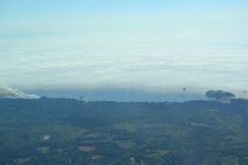
Four planes carrying eight people managed to make it in. My wife and I departed around noon from Creswell, OR (77S) and flew out to near North Bend, OR (KOTH) and then followed the coastal fog and low clouds south down to where Shelter Cove (0Q5) should have been (arrived about 3:10 I think.) But other than seeing the homes on the hills above the fog layer that had lifted to be a low cloud layer, the only hole appeared to be over the water on the south end of the runway. I decided to divert to Garberville - but about 2/3rds of the way there I decided I gave up too easily, so flew back and took another look. This time I approached from the south and descended toward the south hole to take a good look through it at a low angle. I could just see the numbers for runway 30 by flying to the right of the extended runway center line. But that was it. Would have required some ess turning at low altitudes to line up for landing. I gave up and landed in Garberville. 3.6 hrs on the Hobbs to fly 233.5nm.
Took an hour for the shuttle to arrive and another hour to get to the hotel. $100. I suspect it is one of the few places in the U.S. where a rental plane is faster (and cheaper) to go 12.4nm.
Met John, focal_plane, Kimberly, and their significant others. We had a nice dinner at the restaurant that Kimberly had made reservations for and later we all swapped lies around the hotel's outdoor fire pit. Being an easily tired old man, I (and the wife) left the group around midnight.
On the flight back I took a more direct route back home and put 2.5hrs on the Hobbs. A head wind versus a tail wind made a difference too.
It was fun but exhausting - I regret not having arranged to stay two or three nights like John and focal_plane did.